Acumulación de flujo
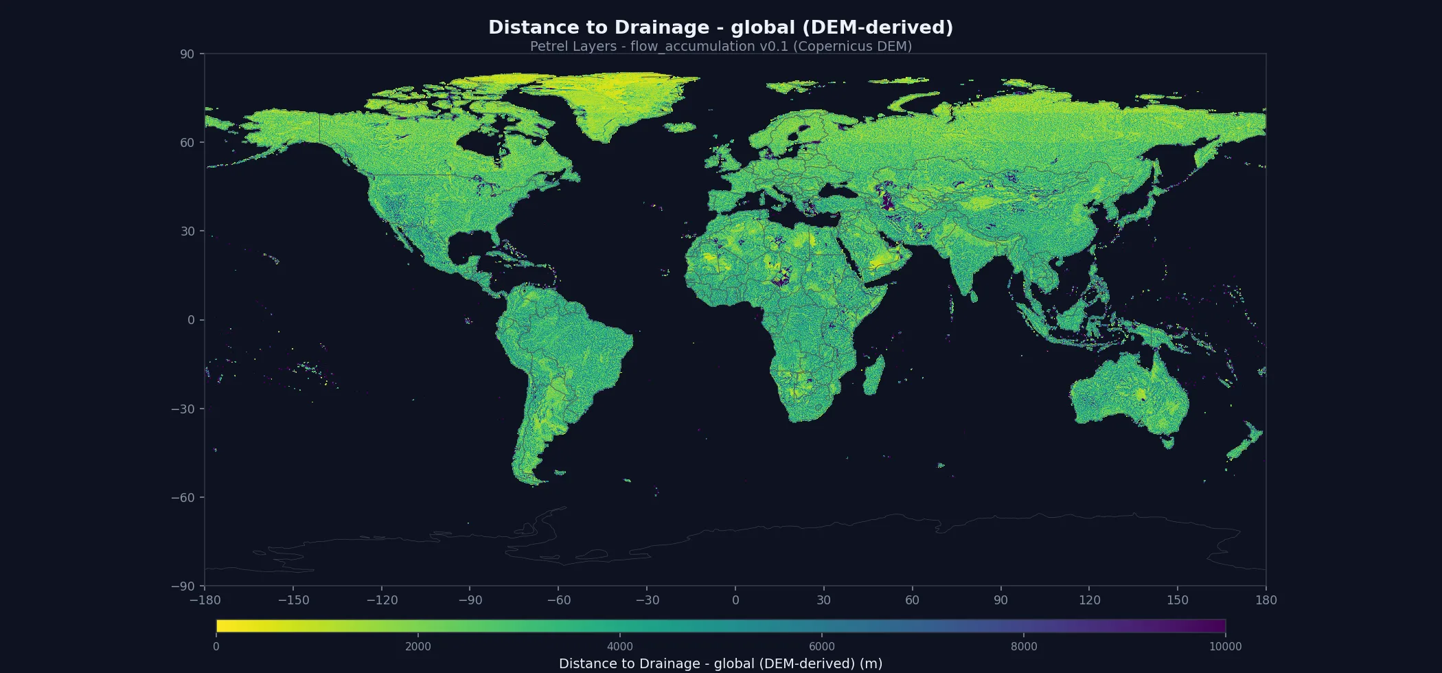
Un conjunto de datos de drenaje gratuito para la comunidad: distancia al drenaje y TWI a 278 m, derivados del DEM abierto de terreno desnudo GEDTM30, por lo que se integran en cualquier stack sin ataduras copyleft ni obligaciones heredadas (CC-BY-NC; las entradas CC-BY se acreditan en el paquete). Las mismas capas alimentan las cadenas de deslizamiento, erosión del suelo, inundación y lahar de Petrel. La v0.3 está validada CUANTITATIVAMENTE: el área vertiente ya se reconcilia entre teselas, de modo que la captación de cuenca en nueve estaciones de aforo alcanza el 90.0–100.4% del área publicada aguas arriba (Amazonas 99.8%, Misisipi 99.4%, Ganges 100.3%, Volga 100.4%) frente al 2.5–19.3% de la v0.1. ⚠ Límites conocidos: las cuencas más llanas siguen subestimando (Ural 90.0%, Amu Daria 94.3%); el sesgo bajo del TWI de la v0.1 en grandes cuencas está resuelto (el residuo que implica la captación restante es inferior a 0.11 unidades), pero el TWI está limitado a 35 y ese techo se alcanza: el 0.13% de las celdas terrestres y el 12.9% de las celdas con más de 1000 km² de drenaje (Volga 22.9%, casi todas en superficies de embalse, que son planas y se saturan por construcción); cuando importe la magnitud del drenaje, use el área vertiente en lugar del TWI; la distancia se satura a 50 km en islas demasiado pequeñas para contener un cauce modelado (118 km² en todo el mundo), donde el valor significa «no hay cauce modelado en esta tierra» y no una distancia; y los lagos ajenos a los ocho embalses del Volga/Kama conservan el enrutado por DEM, por lo que la salida modelada de un lago grande puede no ser la real.
Qué incluye el paquete
2 GeoTIFF globales de ~278 m (9 arcsec) (~7.6 GB en total) más el conjunto completo de documentación. Todos los archivos son Cloud-Optimized GeoTIFF con teselado interno y pirámides de resolución: rápidos tanto para descarga masiva como para lecturas por ventana.
Método
Entradas · DEM de terreno desnudo GEDTM30 v1.2 (CC BY 4.0, atribución obligatoria — incluye los avisos de Copernicus WorldDEM y JAXA AW3D30 que hereda) + HydroLAKES v1.0 (CC BY 4.0) + Natural Earth (dominio público): todas permisivas, sin obligaciones copyleft heredadas
Etiquetas de entrenamiento · —
Método · pysheds D8 (relleno → resolución de llanos → dirección de flujo) sobre el DEM de terreno desnudo GEDTM30; el área vertiente se reconcilia entre teselas por iteración; ocho embalses del Volga/Kama se enrutan como nodos de flujo; los cauces se definen con un umbral de ÁREA, y la distancia euclídea + el TWI se derivan por celda
Documentación
Abierta — no requiere cuenta. Los datos de abajo requieren una clave de API gratuita.
- README — punto de entrada e inicio rápido
- Metodología — cómo se construyó el modelo
- Ficha de modelo — uso previsto, sesgos y limitaciones
- Fuentes de datos — citas de los datos de entrada
- Informe de validación — precisión y limitaciones conocidas
- Registro de cambios — evolución de las versiones
- Licencia — condiciones de uso de esta capa
- Cita — cómo citar este conjunto de datos
- Uso de la API — fragmentos de código
- Descarga masiva — obtener el paquete completo
Descarga
Gratis para uso académico, de investigación y otros usos no comerciales. Requiere una cuenta.
# $PETREL_API_KEY = your API key (tlk.…) from the dashboard — free tier works.

# 1. Fetch 1-hour signed URLs for every file in the bundle:
curl -s -H "X-API-Key: $PETREL_API_KEY" \
  https://api.petreldata.io/v1/layer/flow_accumulation/v0.3/bundle > bundle.json

# 2. Download the full layer (~7.6 GB):
mkdir -p flow_accumulation_v0.3
jq -r '.files[] | [.url, .name] | @tsv' bundle.json | \
  while IFS=$'\t' read -r url name; do
    curl -s "$url" -o "flow_accumulation_v0.3/$name"
doneLicencia y cita
Licencia: CC-BY-NC-4.0. Gratis para uso académico, de investigación y otros usos no comerciales. Para licencias comerciales, escribe a petreldata.io@gmail.com.
Cita:
Petrel (2026). Petrel Flow Accumulation v0.3.
https://petreldata.io/layers/flow_accumulation
CC-BY-NC-4.0
Historial de versiones
- The v0.1 drainage under-count is fixed, not just documented. v0.1 derived flow per 10° tile, so any catchment crossing a tile boundary was truncated. Measured at reference gauges with published upstream areas, v0.1 captured 2.5–19.3% of true drainage. v0.3 captures:
- Drainage is measured in area, not cells, across latitude. A grid cell is a different area at every latitude, and an earlier build re-counted drainage at the receiving tile's cell size wherever a river crossed a north–south tile seam: the Mississippi read 108.6% (it flows south, into larger cells) and the Nile 90.0% (north, into smaller ones). v0.3 carries drainage in area units across every seam.
- Large reservoirs route through, not around. Flat water gives a DEM no gradient, and the Volga was severed inside the Kuybyshev Reservoir where its confluence with the Kama sits on a tile seam (an earlier build read 15.5% at Volgograd). The eight Volga/Kama reservoirs (Rybinsk, Cheboksary, Kama, Votkinsk, Nizhnekamsk, Kuybyshev, Saratov, Volgograd; HydroLAKES polygons, CC BY 4.0) are now treated as nodes: everything entering a reservoir leaves at its dam and follows the mapped river (Natural Earth centerlines, public domain) to the next. Other lakes keep DEM routing.
- TWI is corrected on major rivers. TWI = ln(a / tan β) is a logarithm of accumulation, so v0.1's truncation read straight through. Recomputed from the corrected network, TWI rises +2.70 units on the Amazon mainstem (drainage > 1M km²) and is unchanged on hillslopes — the v0.1 note predicted 1.7–3.7 units low on major basins, and that is what it was.
- Channel threshold is now an area, not a cell count. v0.1 used 1000 accumulated cells, which is 77 km² at the equator but 39 km² at 60°N, so the definition of "a river" drifted with latitude. v0.3 uses a fixed 1 km² everywhere, giving a denser and latitude-consistent stream network; median distance-to-drainage over the Amazon tile drops from 3,345 m to 393 m.
- Bare-earth terrain and a true land mask. Built on GEDTM30 bare earth (buildings and canopy do not dam a river), and the flow network is now masked to the canonical GSHHG-f shoreline. v0.1 routed the ocean as if it were flat terrain, which inflated coastal cells.
- Closed basins terminate. Water reaching the Caspian, the Aral, Lake Chad, Lake Eyre, the Tarim or a Saharan sebkha now ends there, as it does in nature, instead of being pushed onward. Sinks are derived from the DEM by depression-fill depth, not a hard-coded list.
- Known limitations.
- The Ural is under-counted (~90% at Atyrau) and the Nile and Amu Darya sit at 94–97%: DEM routing through flat steppe and delta terrain still loses tributary area at a few points. Treated in a later release.
- Lakes other than the Volga/Kama cascade keep DEM routing. Inside a large flat lake the flow direction is arbitrary; drainage entering a lake is conserved, but where it leaves may differ from the true outlet. A global lake-node treatment was built and measured; it fixed the Volga and broke four other basins at floodplain lakes, so it is not shipped.
- Zoomed-out views no longer show values over open ocean. Distance to drainage is capped at 50 km, which encodes one step below the NoData code, so building reduced-resolution overviews by blending mixed land/ocean cells could land exactly on the cap. Scattered ocean pixels appeared in zoomed-out maps, including in v0.1 and v0.2. The band now builds its overviews without blending.
- Small islands saturate the distance cap. An island too small to carry a 1 km² channel has no channel at all, so every cell on it reads the 50 km ceiling. That is 1,683 cells worldwide (118 km², 0.00007% of scored land) — the Coral Sea cays, the Bahamas, the north-west Hawaiian atolls, the Marianas. Read it as "no modelled channel here", not as a distance.
- TWI saturates on the largest rivers. It is a logarithm of contributing area capped at 35, so a correction to drainage of tens of percent moves it by a fraction of a unit and not at all where it is already at the cap.
- Distance-to-drainage and TWI are per-cell terrain indices, not flood extents; see the layer template for intended use.
- Initial release. Flow accumulation and its drainage sub-layers derived entirely from the Copernicus GLO-30 DEM (pysheds fill → flow-direction → accumulation), so the product is Petrel-owned and carries no third-party redistribution obligations. Ships two sub-layers at ~278 m (9 arcsec) globally: distance-to-drainage (metres to the nearest channel, ≥1000 accumulated cells) and the topographic wetness index (TWI). Raw accumulation is held as an internal intermediate for this vintage.
- A commercially-clean replacement for HydroSHEDS/HydroRIVERS. Built as a drop-in drainage layer whose single permissive input lets it be both given back to the community (CC-BY-NC-4.0) and embedded cleanly inside Petrel's paid hazard models — the copyleft-flavoured HydroSHEDS licence never touches them.
- Native-honest resolution. Ships at the true 9 arcsec derivation grid (_278m), not an interpolated 90 m; the filenames carry the real resolution.
- v0.1 caveat — QUANTIFIED 2026-09-09, and TWI is affected. Derivation is halo-tiled (~110 km overlap), so accumulation is under-counted wherever a catchment crosses tiles. ⚠ RE-MEASURED 2026-09-11 — the figures below replace an earlier set (Amazon 7.8%, Mississippi 10.4%, Congo 17.5%, Nile 22.7%, Danube 30.1%) that was measured with the wrong instrument and UNDERSTATED the shortfall. Those took each 10-degree tile's maximum cell as the basin value; a tile maximum is whatever river is largest in that box, and on a network that had no land mask it was frequently seawater draining into a coastal cell rather than a river at all. Re-measured at reference gauges with published upstream areas, the capture is:
- Free, non-commercial Layer. Distributed under CC-BY-NC-4.0; a derived input data product rather than a paid Hazard. Commercial use is licensed separately.